Chapter 12 - Legal Descriptions
Learning Objectives
At the completion of this chapter, students will be able to do the following:
1) Provide at least two examples of a legal description of land.
12.1 Methods of Land Description
Transcript
Introduction to Methods of Land Description
When land ownership began there had to be a way to define the boundaries of a property so people knew where their land ended and their neighbor’s land began. There had to be a way to define the perimeters of a person’s property. Natural boundaries served as handy reference points, until the tree blew down or the stream changed course. A better way needed to be invented, one that would be more permanent and reliable. The methods used evolved as the shapes and size of properties changed.
In our everyday world, we rely on street addresses to locate property, and you might think that street addresses would be the best way to identify property. It’s certainly one of the simplest. However, while they are convenient, street addresses are not always reliable. Not only can address numbers change, the whole name of the street can also be changed. What are some reasons this might happen? Sometimes the streets are renamed by request from the fire department or police in order to make emergency location easier, or the residents might request a change. In any case, if the street address was the primary way of identifying the property, these changes would create chaos, because people wouldn’t know where the old street name and number went, or how to find the new one.
That’s why using a legal description is the most accurate way to identify real estate. A legal description can be long and look complicated, but it’s a more precise method of describing where a property is located. Why is this so important? You can imagine the problems if a property was bought and sold, a house built and a family moved in, only to discover it was in the wrong spot. Or worse, the building straddled two different properties, with two different owners. It would create headaches that could have been avoided if the correct legal descriptions had been verified.
The importance of using accurate measurements cannot be overstated. How explicit should it be? The legal description should be detailed enough for a surveyor to be able to locate the property using that information alone.
The legal description appears in several places in real estate paperwork, such as sales contracts, mortgage documents, deeds, title information and more. It’s used to trace the history of a property to ensure clear title and lenders need it to make sure they have the proper security for the loan. Everywhere it appears it should be checked carefully to confirm the description is correct.
What are the methods of description?
There are three common methods used to describe real estate: metes and bounds, government survey, and lot and block. Here’s a closer look at how they work.
Metes and Bounds
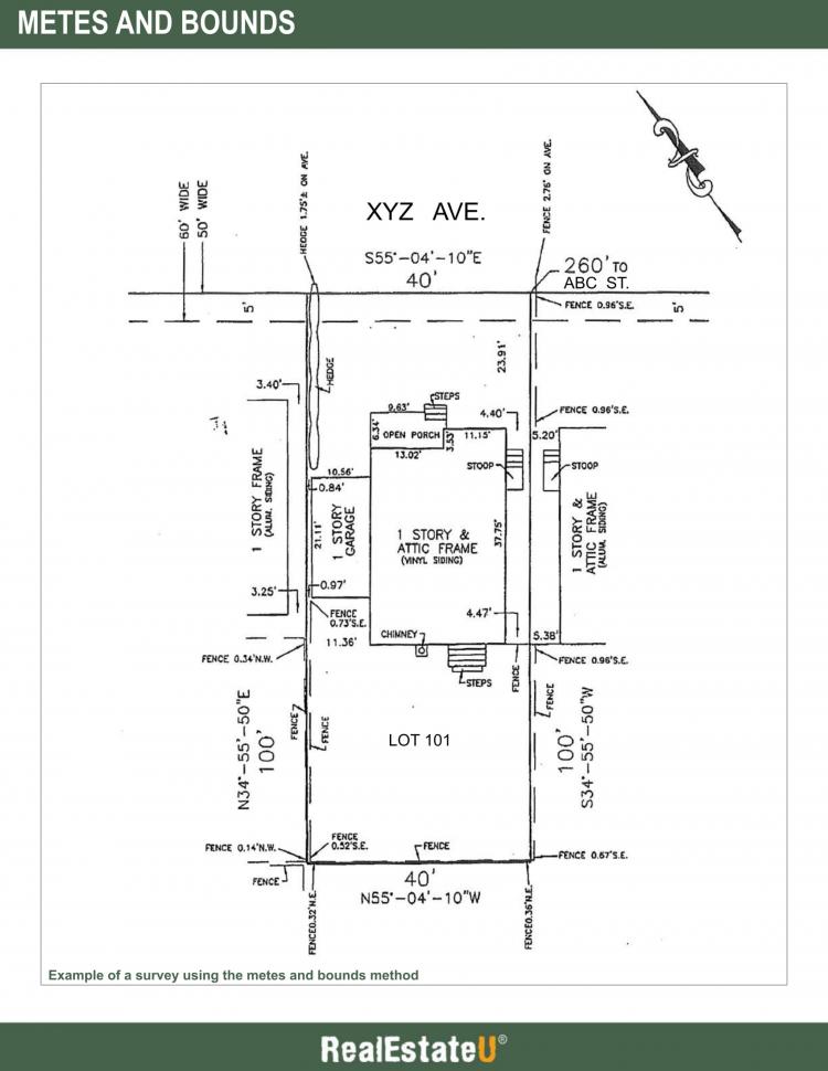
Metes and bounds is a term used in describing the boundary lines of land, setting forth all the boundary lines together with their terminal points and angles. Metes are the length or measurements, and bounds, or boundaries, is a description often used when a great deal of accuracy is required. It’s more common when describing non-subdivision property or large tracts of land, while lot and block identification is usually associated with subdivisions. Sometimes both are used.
The metes and bounds surveying system has been around since the original US colonies, and it’s the oldest system of land measurement. Today the tools are more technical and precise, with the use of computers, satellites, and global positioning systems (GPS) to help identify land. However, the purpose remains the same, to describe the boundary lines that define a piece of real estate, with distances, directions, and angles. The metes and bounds description is recorded on the subdivision map and deeds.
Some of the terminology used with the metes and bounds description includes monuments, benchmarks, and point of beginning (POB).
Monuments are visible markers, benchmarks refer to elevation, and POB means the metes and bounds measurement both begins and ends at the same place. The POB monument is often an iron pin or concrete pillar, set by an engineer or surveyor. The POB can begin at the actual monument or a specified distance and direction from the monument. Regardless, all descriptions must return to the POB, closing the geometric description, to be valid.
Beginning at the POB, the description tells how far and in which direction to go from that point. Then it says how far and which angle to go from there to the next point, then again to the next, until it reconnects with the place where it began.
An example would be S23°W 200 feet. This is a compass degree bearing with S being the compass point, south, and 23 being the number of degrees and another compass point, W, or west, or 23 degrees west of south.
The angular measurements use degrees, minutes, and seconds to define the parcel. Minutes and seconds, in this instance, refer to fractions of degrees and they are used when extreme accuracy is needed.
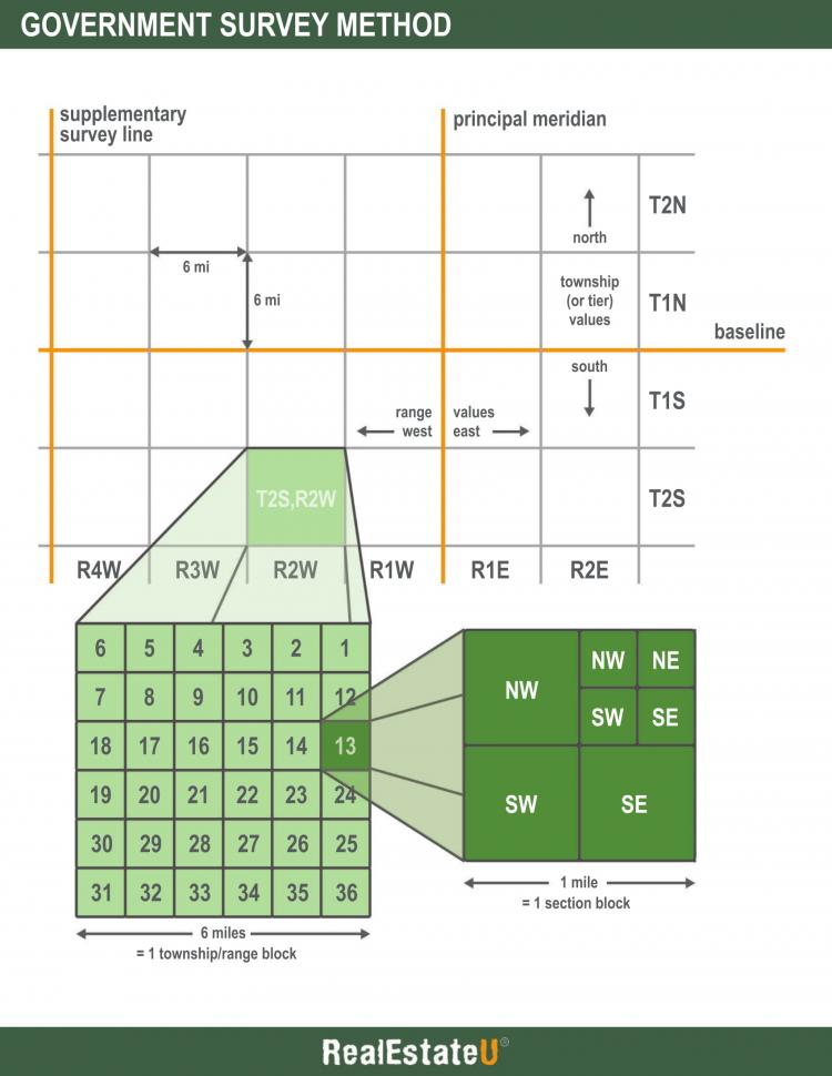
Government Survey
The government survey system began in 1785, and is a system that uses two perpendicular lines: a baseline and principal meridian. This system, also called the geodetic or rectangular survey system, is used in many areas of the United States, most commonly in the west.
You’ve probably seen maps that have grid lines, cutting the land into squares. This would be an example of a government survey, using baselines and meridians.
The baseline runs east-west, and the principal meridian runs north-south. Then lines are drawn about every six miles from the baseline and principal meridian. The north-south lines are called range lines and the east-west lines are called township lines. The six-mile by six-mile squares are called townships.
The townships are divided into 36 tracts. Each of the tracts is a mile square, and these are called sections. A section is 640 acres.
The numbering of the sections is unique. The numbering style is an ancient format, alternating lines that go in opposite directions. When you look at the grid, the number 1 is in the top right corner, with 2-6 running across to the left top corner. Then it drops down one square to the number 7 that runs across to the box on the far right through the number 12, with number 13 directly under it. The numbering goes from top right to top left, then row 2, left to right, row 3 is right to left, continuing through the final square, 36, on the bottom right.
While the government survey description is pretty straightforward for large parcels of land, when it comes to smaller pieces of land, the description becomes longer and longer in order to get down to the finer details. This can become unmanageable, so a different system is commonly used for subdivisions.
Some terminology used in government survey would be meridians, baselines, standard parallels, guide meridians, townships, and sections. Guide meridians run north from the baseline, or standard parallels, at 24-mile intervals east and west from the principal meridian. Guide meridians end where they intersect with the standard parallels.
Lot, Block and Subdivision
The lot and block survey system, sometimes called the recorded plat, or recorded map survey system, is used to locate and identify land, usually lots, in subdivisions.
It’s the most recent survey system, developed when tracts of land began to be subdivided. A plat map, or cadastral, delineates the lots in a subdivision and is recorded as a legal description. Lots are generally sold as one piece, and blocks have a group of lots that are adjacent, with the blocks separated by roads throughout the subdivision.
In addition to the lots and blocks, a plat map usually includes details like streets, sections, monuments, and public easements. It also might include floodplains, elevation, and covenants. Each description includes information on the platted subdivision phase, the block (if relevant), and the individual lot, referenced by the book and page where the information is located. An example would be Lot 2 of Block 3 of the Mountain River Subdivision plat as recorded in Map Book 47, Page 5 in the office of the public recorder’s office.
To see how these measurements are applied to the land as it’s measured, divided, and sold, here’s an example.
Let’s say a landowner has a large piece of land and wants to subdivide it into small, residential lots. The metes and bounds, or government system, has been used to describe the land. The parcel, which our landowner wants to divide, is a quarter-quarter-section, or 40 acres.
The 40 acres needs to be subdivided into smaller residential lots with appropriate streets, easements, and access. It may be divided into several phases with separate subdivisions, each with a plat map. The plat map, created by a licensed surveyor, will lay out the details for the subdivision using blocks. Each lot within the plat map can also be described using metes and bounds, too. They are not mutually exclusive.
The subdivider will submit a preliminary plat map to the city or county for review. When improvements have been done and the subdivision is approved, a final plat map is filed and recorded. Prospective buyers often get a copy of the plat map to look at to learn more about the shape of their lot and the way the neighborhood is divided.
Surveying land depends on three basic things: distance, elevation, and angles. If we were to survey a property that was 160 feet by 120 feet rectangle, we’d begin at the southwest corner and go 120 feet north. Then we’d turn at a 90-degree angle, headed east, and go 160 feet. We’d take another 90-degree angle, going south, for the next 120 feet and a final 90-degree turn, going west for 160 feet to the POB, and we’ve described the property.
That’s the basics for measuring out a rectangular lot. How would that look for an irregular lot, for example, one with only three sides? Let’s start at the southwest corner and go 130 feet north, turning at a 45-degree angle heading southeast for 130 feet, then take a final 45-degree angle southwest right back to the beginning point, the POB, to outline a triangular parcel.
While it’s unlikely you’ll ever need to survey a property, as that task requires a licensed surveyor or engineer, you could find yourself on a property with a buyer who is interested in locating the lot boundaries. As you stare at the plat map, and wade through the weeds to uncover the markers, you’ll be glad you took the time to understand the principles of how property is surveyed so you can help find the markers that pinpoint the corners of the lot. Of course, you should always remember that your estimates are only that. A reliable verification of lot lines must be done through licensed surveyors or engineers.
In any case, you’ll be glad that you know how property is described and identified so that you can help your buyer or seller understand what they are looking at when they review the plat map or see a legal description, and you can explain why an accurate description is so important.
Key Terms
Base and Meridian
Imaginary lines used by surveyors to find and describe the location of private or public lands. In government surveys, a base line runs due east and west, meridians run due north and south, and are used to establish township boundaries.
Government Survey
A method of specifying the location of parcel of land using prime meridians, base lines, standard parallels, guide meridians, townships and sections.
Lots and Blocks
A legal description of land used for plotted properties, stating the number, lot, and block in a particular sub-division.
Metes and Bounds
A term used in describing the boundary lines of land, setting forth all the boundary lines together with their terminal points and angles. Metes (length or measurements) and Bounds (boundaries) description is often used when a great deal of accuracy is required.
Section
Section of land is established by government survey, contains 640 acres and is one mile square.
Survey
The process by which a parcel of land is measured and its area is ascertained; also the blueprint showing the measurements, boundaries and area.
Townships
In the survey of public lands of the United States, a territorial subdivision six miles long, six miles wide and containing 36 sections, each one mile square, located between two range lines and two township lines.
12.1a Metes and Bounds Diagram
Please spend a few minutes reviewing the Diagram below:
12.1b Government Survey Diagram
Please spend a few minutes reviewing the Diagram below:
12.2 Description of a Condominium Interest
Transcript
A condominium is real property; however, the ownership rights are different from a single-family residence. With a condominium, there is a common area which is owned jointly by all the condo owners, and then the airspace of the condominium unit space itself, which is owned individually.
The owner of a condominium owns the inside of the unit, often just from the wall surface inward, and a share of all the exterior features and amenities, such as the yard, hallways, driveways, the structure of the building, and the land on which it sits, are part of the commonly shared property.
Because each unit involves the interior of a unit, the elevation can be part of the description, and if basements, ground floors, second floors or higher are involved, then the description might include a reference to an official datum, or designated surface, used to measure elevations. The space is described in the condominium plan, recorded final map, or parcel map.
The legal description generally includes the word condo or condominium, as well as the Tract number, Lot number, Unit number, and Building number.
Since ownership is different, this can affect insurance, financing, and other factors for a buyer, so it’s important to determine whether a property is truly a condominium or not.
Building style, or architecture, is not always a reliable indicator. To be sure of whether a property is a condominium or not, the best determination would be the legal description. The legal description can be found on the deed to the property.
Key Terms
Condominium
An estate in real property wherein there is an undivided interest in common in a portion of real property coupled with a separate interest in space called a unit, the boundaries of which are described on a recorded final map, parcel map or condominium plan.
12.3 Preparation and Use of a Survey
Transcript
What is a survey?
A survey can mean one of two things: either the process of measuring and determining the area of a parcel of land or the blueprint, sometimes called the land survey map, that describes the measurements and land area.
Surveys are performed by licensed surveyors who generally use the metes and bounds method of describing the property. The survey contains a lot of information that is important for the buyer to know.
In addition to describing the lot lines and their angles, the survey can confirm the dimensions and how the home, garages, sheds or other buildings are situated on the lot and their orientation to true north. Any easements, setbacks, or encroachments will be described in the survey. Landscaping, including paved or grassy areas, might also be part of the description.
When to use a survey when buying or selling property?
In order for the buyer to know exactly what they’re purchasing, the buyer and the real estate agent may look for the survey stakes, or markers, in order to see where the property boundaries lie. If the survey stakes are not visible, or cannot be found, the seller may have to pay to get the property resurveyed. Even if the stakes can be seen, the buyer can still decide to have a new survey done, but it would likely be at the buyer’s expense.
If a new survey is ordered and there are discrepancies, the seller would need to resolve the inconsistencies, and in most cases, pay for the survey.
A new survey also will be ordered if the lender requires it.
How might this come up in a real estate transaction?
Imagine, for example, a homeowner is selling a home with a fenced yard. However, the prudent buyer has requested a survey because the monuments, or markers, are no longer visible. To everyone’s surprise, when the survey is completed, it’s discovered that the fence is sitting on the neighbor’s land. If it’s a minor encroachment, the parties might decide to leave it as is. If not, there may be compensation for the land that’s involved, or even the fence being removed and reinstalled.
If the fence is replaced, or other alternations have been made, a new survey should be done to protect the parties, and make sure everything is as expected.
Key Terms
Survey
The process by which a parcel of land is measured and its area ascertained; also the blueprint showing the measurements, boundaries and area.
3.4 Power of the Commission to Issue, Suspend, or Revoke a License
Transcript
Anyone who holds a license for real estate in Georgia is bound by the rules issued by the Commission. The Commission has broad powers including the right to revoke, suspend or issue a real estate license to any person as well as the right to regulate the rules pertaining to the issuance of a license.
The Georgia Code grants the Commission the following powers.
The Commission can regulate all licensing matters including the issuing, suspension, revocation, and censure of any licenses. Each applicant agrees that the Commission has this power as part of their initial application, or application for renewal.
In addition, should the Commission feel it is necessary to investigate or examine a broker's trust account, they have the full authority to hire or enter into a contract to assist them with the fulfillment of such examination. There are some limits on this authority; however, since the Commission must be able to demonstrate such examination requires specific expertise including that of an accounting or legal expert. In these cases, the Commission maintains full supervisory authority over such experts. Final decisions in any cases are made by the Commission and not by any expert whom the Commission hires to undertake the review.
It is important to remember the Commission has broad power to collect fees as well. The fees may be used to pay any and all fees required to pay such experts provided that any funds remaining at the end of the year are turned over to the State Treasurer for deposit to the State Treasury. No fees remaining at the end of the fiscal year may be carried over from year to year.
One of the more serious responsibilities of the Commission is establishing what behavior is acceptable for those who are license holders. The Commission has previously established it is the responsibility of a real estate license holder to act in the interest of the public. Therefore, license applications are reviewed and will not be approved should the applicant have a prior felony conviction. It is also worth noting the Commission has determined that should an applicant have pled no contest or agree to treatment as part of a first-offender program, this person may also be denied a license.
The Commission may review applicants at their discretion should more than five years have passed, and the applicant has fulfilled their debt by fulfilling the terms of any jail time, restitution, etc. which were a result of the conviction or arrest. The Commission retains the right to insist that applicants with a prior conviction be able to effectively demonstrate they have successfully established their competence, honesty, and can demonstrate they can be trusted. The Commission has the sole discretion to request such documentation and has the authority to determine how the applicant must document their claims of having rehabilitated themselves.
In cases where the applicant is applying for an associate broker or a broker’s license, should there have been a conviction involving a financial crime, or one of moral turpitudes, the waiting period before being reconsidered will be 10 years. The 10 years begins at the time of conviction, release from incarceration, or fulfillment of sentencing whichever of these events occurs last.
False statements, violation of fair housing law, or pending criminal charges shall be grounds for denial of a license and in some cases, for refusal to issue a license at any time. Should an active licensee be convicted of a crime, the Commission may suspend their license within 60 days of the conviction. Additionally, license holders who are facing mortgage foreclosure or are in default of child support payments will also have their license suspended, or an initial or renewal license application denied. Such suspension, or denial shall continue until such time as the applicant has made appropriate arrangements to address the issue.
Applicants for a real estate license may have the opportunity to rebut a denial, revocation or suspension of their license through a hearing. These hearings will take place in the location where the Commission has established their primary place of business. Should an applicant not be satisfied after such a hearing, they may be entitled to request the superior court of Georgia to review their case. The court review will also take place in the county where the Commission does business.
Key Terms
COPYRIGHTED CONTENT:
This content is owned by Real Estate U Online LLC. Commercial reproduction, distribution or transmission of any part or parts of this content or any information contained therein by any means whatsoever without the prior written permission of the Real Estate U Online LLC is not permitted.
RealEstateU® is a registered trademark owned exclusively by Real Estate U Online LLC in the United States and other jurisdictions.